


Fairview Precinct, Matanuska-Susitna Borough, Alaska
About
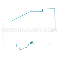
Outline

Summary
| Unique Area Identifier | 523445 |
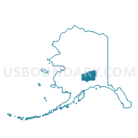
| Name | Fairview Precinct |
| County | Matanuska-Susitna Borough |
| State | Alaska |
| Area (square miles) | 57.84 |
| Land Area (square miles) | 33.52 |
| Water Area (square miles) | 24.32 |
| % of Land Area | 57.95 |
| % of Water Area | 42.05 |
| Latitude of the Internal Point | 61.52802770 |
| Longtitude of the Internal Point | -149.41359080 |
Maps

Graphs
Select a template below for downloading or customizing gragh for Fairview Precinct, Matanuska-Susitna Borough, Alaska


Neighbors
Neighoring Voting District (by Name) Neighboring Voting District on the Map
- Butte Precinct, Matanuska-Susitna Borough, AK
- Eklutna Precinct, Anchorage Municipality, AK
- Knik-Goose Bay Precinct, Matanuska-Susitna Borough, AK
- Peters Creek No. 2 Precinct, Anchorage Municipality, AK
- Seward Meridian Precinct, Matanuska-Susitna Borough, AK
- Snowshoe Precinct, Matanuska-Susitna Borough, AK
- Springer Loop Precinct, Matanuska-Susitna Borough, AK
- Trunk Precinct, Matanuska-Susitna Borough, AK
- Wasilla Lake Precinct, Matanuska-Susitna Borough, AK
- Wasilla No. 2 Precinct, Matanuska-Susitna Borough, AK
Top 10 Neighboring County Subdivision (by Population) Neighboring County Subdivision on the Map
- Anchorage census subarea, Anchorage Municipality, AK (291,826)
- Matanuska-Susitna census subarea, Matanuska-Susitna Borough, AK (88,995)
Top 10 Neighboring Place (by Population) Neighboring Place on the Map
- Anchorage municipality, AK (291,826)
- Knik-Fairview CDP, AK (14,923)
- Wasilla city, AK (7,831)
- Gateway CDP, AK (5,552)
Top 10 Neighboring Unified School District (by Population) Neighboring Unified School District on the Map
Top 10 Neighboring State Legislative District Lower Chamber (by Population) Neighboring State Legislative District Lower Chamber on the Map
- State House District 15, Rural Mat-Su, AK (25,974)
- State House District 14, Greater Wasilla, AK (23,682)
- State House District 13, Greater Palmer, AK (23,507)
- State House District 16, Chugiak-South Mat-Su, AK (21,559)
Top 10 Neighboring State Legislative District Upper Chamber (by Population) Neighboring State Legislative District Upper Chamber on the Map
Top 10 Neighboring 111th Congressional District (by Population) Neighboring 111th Congressional District on the Map
Top 10 Neighboring Census Tract (by Population) Neighboring Census Tract on the Map
- Census Tract 1.01, Anchorage Municipality, AK (5,736)
- Census Tract 13, Matanuska-Susitna Borough, AK (5,461)
- Census Tract 11, Matanuska-Susitna Borough, AK (5,364)
- Census Tract 1.02, Anchorage Municipality, AK (5,259)
- Census Tract 6.04, Matanuska-Susitna Borough, AK (4,734)
- Census Tract 6.01, Matanuska-Susitna Borough, AK (4,481)
- Census Tract 9, Matanuska-Susitna Borough, AK (2,544)